
Albenga - Aquila d'Arroscia
Rio Ferraia Waterfall
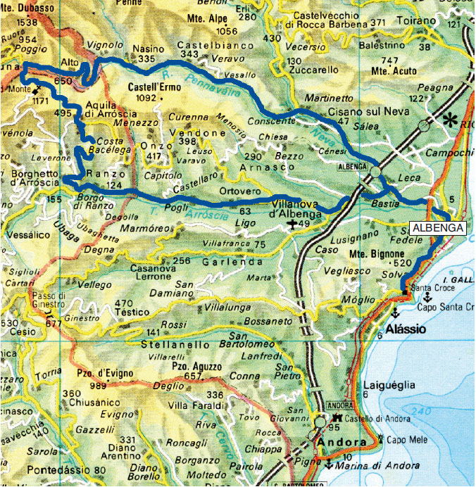
Nasino - Alto - Caprauna - Albenga
Albenga - Via Julia Augusta - Alassio
From Albenga, on the State Road 453 you’ll reach Ortovero (km 11) and Pogli (km 13); a little further on you will enter the administrative territory of the province of Imperia and will arrive to Borgo di Ranzo (km 16).
Continuing, leave the State Road and, on the Provincial Road 14, you’ll begin to climb the sunny coast dotted with villages and vineyards passing by the areas of Caneto and Costa Parrocchia; at the next junction leave the Provincial Road heading towards Leverone and continue to climb on the Provincial Road 78 to Borgo Montà and then to Aquila d'Arroscia (km 25).
Cross the whole town and then, keeping the left at the numerous crossroads, you will reach the Provincial Road again, where, still on the left for one last time, you will go a hundred meters before entering (junction on the right) into the little road leading to Colle di San Giacomo (755 m - 28 km), a pass that connects the Arroscia Valley that you have just ascended with the Pennavaire Valley.
On the hill, in a panoramic position, stands the small church dedicated to San Giacomo, with a small road at the side that in about 15 minutes brings you near the evident ruins of Castello dell'Aquila (827 m) that can be reached by path.
Continue on the side of Val Pennavaire, climbing slightly until you find a dirt road that branches off to the right (km 32- 830 m).


Excursion to Rio Ferraia waterfall
(trekking)
Leave the paved road and take the dirt road to the right, descend with two hairpin bends into the woods, reaching the Ferraia Dam (approximately 780 meters) and the lake, barely visible in the vegetation. The small road narrows further in its descent next to Rio Ferraia.
Take the small tunnel of the aqueduct, a little over fifty meters long (a flashlight would be useful but not indispensable), where you can encounter the rare Ocellata Salamander.
Just outside the tunnel, the waterfall is already visible and can be reached in 10 minutes on foot.
The water falls from a height of about 25 meters and at the base forms a small pond but, since it is located further downstream from the dam, during periods of drought it can remain dry because all the available water is conveyed to the forced ducts.
Near the waterfall, a small path leads to the wide "Arma do Cupà", a cave in which human and prehistoric animal remains have been found and where, in the center, stands a squat stalagmite partially modeled in prehistoric times as a tribute to the god of fertility, having the shape of a phallus.
The return takes place on the same route as the outward journey (2 hours).
Once back to the car, almost immediately the road turns into a good dirt road that passes on the opposite side of the valley engraved by Rio Ferraia and, continuing halfway up the hill with some ups and downs, goes down to cross the Pennavaire Torrent at an altitude of 830 meters to go up again and lead, downstream of Caprauna (at about 900 meters), into the asphalted road (Provincial Road 107) which descends to Alto (660 m - 44 km). On the town square stands the massive bulk of the 13th century Cepollini Castle.
From Alto, descending through Val Pennavaire - still along the main road (which in the meantime has become Provincial Road 14) and always remaining in the valley bottom - passing the municipalities of Nasino and Castelbianco you’ll reach the confluence with the Neva where you can turn right and, on the more important Provincial Road 582 of Colle San Bernardo, going along the vast plain, you will return to Albenga (km 72).


The Via Julia Augusta
(trekking)
Via Julia Augusta was built at the time of the Emperor Caesar Octavian Augustus between 13 and 12 BC to connect Rome to Southern Gaul (although it is likely that other routes already existed).
The new road connected Vada Sabatia (Vado) to La Turbia in Provence, where the majestic monument erected in 7-6 BC stands to celebrate the "pacification" of the many Ligurian tribes.
Later, the road was extended to Arelate (Arles), to connect with Via Domitia (via Domizia) coming from Spain (an itinerary that had already existed for over 100 years).
Finally, with the final subjugation of the Ligurian people, an itinerary was completed which - starting from Rome with Via Aurelia - continued with Via Julia Augusta and ended with Via Domizia in Spain.
Other emperors, including Caracalla, were involved in the reconstruction of the Roman road which was the only land route that crossed the Ligurian west until the early nineteenth century, when Napoleon first and then the Savoys began and completed the coastal road (the current via Aurelia).
It is evident, therefore, how numerous the maintenance interventions of the road must have been over more than 2 millennia.
Very few traces remain of the ancient route, more substantial in the Finale area where remain - in the area of the famous "Roman bridges" including the intact and splendid Ponte delle Fate - sections of Via Julia Augusta that show the grooves carved by the wheels of the carriages on the bare rock; elsewhere, just as in Albenga and Alassio or near Mortola (Ventimiglia), there are some short sections that are probably only accurate medieval reconstructions of the ancient road.
Via Julia Augusta, in the splendid stretch between Alassio and Albenga, is one of the most evocative historical nature trails in Liguria; it develops along the hillside, around 100 m above sea level, it is easily accessible and shows the typical colors of the Mediterranean scrub.
The vestiges of the necropolis of the imperial age along the way testify to the importance and richness of the Roman Albingaunum.
Along the way, the vision of the unmistakable silhouette of the Gallinara island accompanies you, so called already in Roman times due to the presence of wild hens.


The itinerary
(trekking)
From the center of Albenga towards Alassio, from Piazza del Popolo cross the bridge over the Centa towards Via Piave. At the roundabout, turn right on Via San Calogero, where you walk a few dozen meters to take an uphill road on the left that leads to Monti.
After a few steps to the left, an indicator with a red square sign indicates the way to follow. After a few hundred meters, you’ll come to "il Pilone", a funerary monument that was previously mistakenly considered the lighthouse of the underlying Roman port of Vadino (here resumed from Sentiero dell'Onda). However, the location is not accepted by all scholars; for some it may be more to the east and closer to the mouth of the Centa.
Still going uphill, you’ll reach a plateau where, just emerging from the ground, there are the few remains of the Roman Amphitheater and a whole series of archaeological remains, essentially family tombs, well explained by illustrative panels.
Among these, the building F stands out for its massiveness, a family tomb from the end of the 1st century AD with a retaining wall, inside which the burials were made.
The building is lined with squared blocks of stone, according to a technique widely used in nearby Gaul (petit appareil) and characterized by a lively and singular decoration obtained by exploiting the different colors of the blocks.
A little further on there is another series of ruins, including the building (D) relating to the remains of a large family tomb also from the 1st century AD.
Looking east, you have a beautiful view of the still nearby Albenga with the Caprazoppa Promontory in the distance.
Past other remains, always diligently described by information panels, after a quarter of an hour you’ll walk on the stretch of road brought to light in 1937 and interpreted by Nino Lamboglia - the greatest popularizer of the things of Liguria - as the only one preserved of the ancient Via Julia Augusta in the area; today, it is believed that this paving is referable to the medieval period and constitutes one of the many renovations carried out over the centuries.
From this point on, the itinerary has mainly an environmental value.
Go up slightly for a few hundred meters until you reach a sign that forces you to take a detour due to a landslide on the original route (which could easily be overcome, but let’s be good citizens and comply with the requirements).
The detour forces you to an extra effort because it takes you to Canelli up to an altitude of 200 meters and extends the journey by half an hour; on the other hand, the view widens beautifully on Albenga where in the foreground on the right you can see the bay of Vadino and, further away, the whiteness of the houses of Loano and Pietra Ligure up to Caprazoppa and the whole arc of the Riviera.
Near, with its characteristic shape of a snail, the Gallinara island. It is curious how this little island, slightly larger than a rock, bears the weight of such an important history.
It now seems historically ascertained that on the island found shelter San Martino, bishop of Tours, who lived there as a hermit for four years from 357 to 361; subsequently, the island saw the rise of a monastic community, later Benedictine, which between the tenth and twelfth centuries reached the top of its prosperity acquiring, thanks to numerous and important donations, large estates in western Liguria and even in France and Spain. A slow but unstoppable decline followed; the island became property of the Diocese of Albenga which sold it to private individuals in 1867; and this remains today even if the island is included by the Liguria Region in the system of protected areas.
From Via Julia Augusta you can identify the sixteenth-century Genoese tower, the manor house - enlarged and reworked several times and which has incorporated the remains of the ancient monastery - and, finally, the twentieth century tiny church built in neo-Gothic style.
Still on the paved road, begin to go down the long Via Giorgio Byron between olive groves and beautiful small villas until you enter the original path, and in about 10 minutes you’ll reach the Church of Sant'Anna ai Monti. Tradition has it that this is a very ancient church - even built before the year 1000 - and that it was the first church in Alassio even before the Church of Santa Croce which you will encounter shortly. In reality there are no certain elements about its foundation. Certainly it has undergone various changes; from the seventeenth century it was used for agricultural purposes and was radically restored only in the 1970s. Today parts of frescoes from the end of the fifteenth century are still visible, but everything is again in a state of neglect.
Below, now in the vicinity of Capo Santa Croce, the view extends beautifully over Punta Murena, on the cove that was the ancient Roman port (now occupied by the famous Baba Beach) and finally on the town of Albenga which extends up to Capo Lena at the mouth of the Centa.
Looking west, you can see Capo Mele stretching out towards the open sea; closer, Capo Santa Croce with the tourist port of Alassio, built around the 1950s, with, at the base of the cliff, the characteristic Cappelletta (little chapel) erected in 1929 in memory of those who fell at sea.
A few more steps and - a quarter of an hour's walk from Sant'Anna, passing under the stone arch that the writer Cecil Roberts called "The portal of paradise" - you’ll arrive to the little church of Santa Croce mentioned for the first time in a seal of Pope Alexander III of 1169 as a priory belonging to the Benedictine monastery of the Gallinara island (of which we talked before). The apse and the left side of the original building remain, characterized by the presence of twin arches separated by pilasters, typical elements of the Benedictine architecture of that period, while the front porch dates back to the sixteenth century. In later centuries the church fell into disrepair and only in the 1970s it was restored and reopened for worship. The custom of getting married in this church is well-established among the people from Alassio.
The view from the belvedere situated a few meters below the church is exceptional. On clear days it embraces the entire coastline bordering the Ligurian Gulf to the east while to the west it is limited by the imposing bulk of Capo Mele.
This concludes the archaeological walk. You just have to go down Strada Romana di Santa Croce and take the bus for the return to Albenga.
In total it’s about 7 km (of which at least 1.5 are due to the deviation caused by the landslide, which hopefully will be fixed in the near future), which can be covered safely in 2 hours and a half, maximum 3 hours.

