
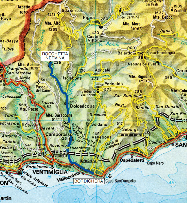
Bordighera - Rocchetta Nervina
From Bordighera, going along the Aurelia, after 4 km you can turn into Val Nervia, where you will soon reach Camporosso (beautiful historical center) and Dolceacqua (km 11) announced by the famous bridge and the looming Doria Castle.
A little further on, turn left into the valley flowed through by the Barbaira stream with a beautiful view over the torrent that runs down to the right and, in a short while, you’ll reach Rocchetta Nervina (km 17).
EXCURSION 1: along the course of Rio Sgorea
(trekking)
In Rocchetta Nervina (220 m), look for Via San Bernardo which - turning into a paved mule track - exits the village and, going upwards, enters the valley, offering suggestive views of the Sgorea Torrent.
After about 2 km (around an altitude of about 450 meters), a detour to the left leads you in a short time to Ponte Cin (431 m). It is about 300 meters of total height difference that can be covered in 2 hours and 30 minutes (round trip).


EXCURSION 2: along the course of Rio d'Oggia
(trekking)
In Rocchetta Nervina (around 220 m), find on the right the entrance to the Vallone flowed through by Rio d'Oggia and, along Via Santa Lucia, you’ll soon arrive to the homonymous little country church (263 m).
After less than ten minutes you will encounter Ponte di Santa Lucia (270 m) on Rio d'Oggia.
The beautiful paved mule track continues along the valley always near the foaming watercourse and after less than 5 minutes it offers the view of another beautiful bridge (280 m) on Rio Castagna near its confluence with Rio d'Oggia.
Another 20 minutes and you’ll reach, at an altitude of 380 meters, another bridge still on Rio d'Oggia.
At this point, unless you are in good shape to continue to Monte Terca or Passo di Gouta it is better to return to Rocchetta Nervina.
Elementary path of just under 200 meters of difference in altitude walkable in less than 1 hour (one way).
In the case of abundant water (in the bed of the stream), it’s a very suggestive path.