
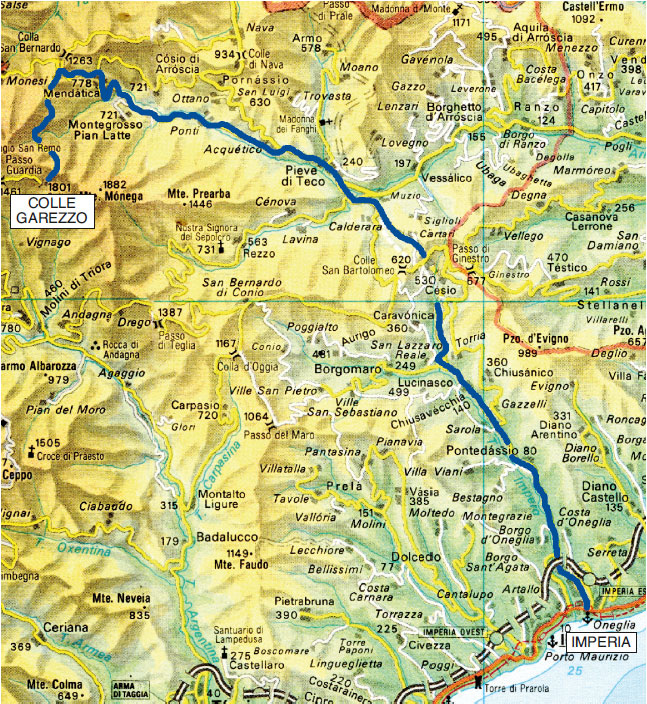
Imperia Oneglia - Colle Garezzo
From Imperia - along the State Road 28 of Colle di Nava, just beyond Pieve di Teco in the Acquetico area – divert to Mendatica (m 782- km 35).
A few steps before entering the village, next to a characteristic fountain, a dirt track develops to the left to Montegrosso Pian Latte. In a short stretch, a detour on the right takes you in view of the small church of Santa Margherita which houses a cycle of frescoes of the 15th and 16th centuries.
EXCURSION 1: Arroscia waterfalls
(trekking)
Next to the small church of Santa Margherita, a grassy lane leads into the little valley where the roar of the abundant waters of the Arroscia stream can already be heard.
After crossing Rio Gruppin on an ancient single-arch bridge, the little road turns into a cobbled mule track (rather slippery when wet) which, with a series of twists and turns, leads you to the Falls (m 1050 - 1080). Difference in height is less than 300 m walkable in 2 hours and 30 minutes (round trip).
Beyond the falls, the path continues up to Poilarocca (1440 m) and merges at an altitude of 1600 meters with the road that goes up to Garezzo: but it is not an itinerary for everyone.
From Mendatica (km 35), the roadway continues to Colle San Bernardo di Mendatica (1263 m - 40 km) and then, unpaved, to Colle Garezzo (1795 m - tunnel at 1772 m - 46 km). A recent landslide has made the transit a little more difficult; it is therefore advisable, even if not essential, to have an off-road vehicle.


EXCURSION 2: Monte Fronté, 2153 meters
(trekking)
Arriving near the tunnel, looking north, you will clearly see a large mule track, also marked by the transit of animals, that, with a regular climb, cuts through the side of the mountain, which is Costa di Monte Fronté, culminating at 2049 meters.
Once you have passed Costa, the summit of Monte Frontè (2153 m) with the white statue of “Madonnetta” will be evident and close, while the imposing Cima di Garlenda (2140 m) rises on the right.
The panorama from the summit is splendid and grandiose with a detailed view of the rocky spur (altitude 2122 meters) overlooking "Le Scalette".
A little further on are Monte Cimonasso and the pink dot of the small Rifugio Sanremo, then the crest that goes up to Mount Saccarello preceded by the white dot of the Statue of the Redeemer and finally the crest that goes up to Bertrand.
In the distance are the Maritime Alps, visible from Capelet Superiore and Cima del Diavolo, up to Rocca dell'Abisso and Frisson; further to the right, the Marguareis group and the mountain ridge towards Pizzo d'Ormea and then, towards the sea, the relief that from Garezzo rises to Monega, descends towards Carmo dei Brocchi and Monte Grande to the sea.
The route is all along a small road with a regular incline and with a difference in height of 370 meters that can be comfortably covered in 1 hour and 30 minutes (return trip in 1 hour / 1 hour and 10 minutes).
Once past the tunnel, the descent to Triora begins. At the crossroads (Passo della Guardia - km 49.5) disregard the road to the right that leads to Collardente; descend to Passo del Pellegrino (m 1398 – km 51) and, finding the asphalt after a short stretch, you’ll reach Triora (km 58) and at the bottom of the valley Molini di Triora (km 63).
Finally, following the flow of the Argentina stream, you’ll arrive to Taggia (km 84), and to the junction on the Aurelia (km 87) and then, to Imperia (km 104).