
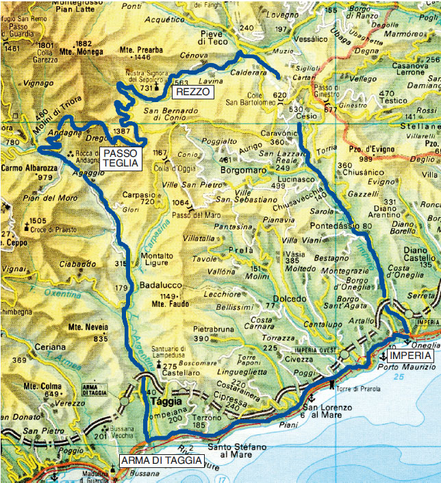
Arma di Taggia - Passo Teglia - Rezzo - Imperia - Arma di Taggia
From Arma di Taggia take the Provincial Road of Valle Argentina which, immediately after Taggia, narrows considerably to climb, always in view of the stream and with a moderate slope, up to Badalucco (km 10), valuable in its oldest core and characterized by two spectacular bridges, one at the beginning and one at the end of the town.
A little further on, on the right, Montalto Ligure appears in a beautiful position at the confluence of the Carpasina Torrent.
Near the junction (km 12), the road leaves the old path (still passable with some difficulties, but interesting for the glimpses on the rocky bed of the stream dotted with ponds) to climb halfway up; the panorama gradually widens on both sides of the valley revealing almost depopulated villages clinging to the mountain.
Near the junction appears Triora (776 m), which, with its houses, occupies entirely a mountainous spur dominated by the woody Monte Trono (1189 m).
You are now at the entrance of Molini di Triora (km 24) and, turning right, begins the 12 km climb to reach Passo di Teglia (m 1397 - km 36).
As you keep going, you will encounter the small village of Andagna (729 m), the little church of San Bernardo (759 m) with fairly well-preserved 15th-century frescoes, the little church of Santa Brigida (901 m) placed on a forgotten secondary pass, and Drego (m 1080) near the homonymous Rocca (i.e. fortress), a magnificent viewpoint on Carmo dei Brocchi (m 1610).
EXCURSION 1: from Passo di Teglia to Colle della Mezzaluna
(trekking)
From the Pass towards Colle there are two routes that come together near the so-called Fossa di San Lorenzo.
The one that develops on the slope of the Argentina Valley is more spectacular, but hides some pitfalls, while the classic route - which traces the path of an ancient marenca route - develops entirely on the slope facing the Arroscia Valley and crosses a beautiful beech forest with an almost flat path up to Fossa di San Lorenzo (1386 m), so called because of the presence (on the right) of the ruins of a small country church dedicated to the saint.
In the center of the sinkhole, once occupied by a small pond, rises a square boulder on which a large “coppella” is engraved, while - at the upper edges of the basin, touched by the path that develops on the Argentina side - there is a large inserted stone, perhaps a dolmen or an ancient border sign.
From there it is possible to go up along an unexposed but very steep path, to the summit of Carmo dei Brocchi (1610 m) returning via the same route since there is no path on the slope towards Mezzaluna.
Staying on the main route, you will face the only uphill section on rough paving residues and, after a beautiful pine forest, you will come out into the grassy plateau and soon to Colle della Mezzaluna (1454 m).
Outward route that can be easily done in 1 hour and 15 minutes (total height difference about 200 m).


EXCURSION 2: from Passo di Teglia to Monte Grande
(trekking)
From Passo di Teglia (1397 m), turning left, it is possible to take a small road at the service of the small plants on the summit of Monte Grande which, cutting the slopes of Monte Fenaira (1458 m) and Monte Carpasina (1413 m), reaches Monte Grande (1418 m) in about 1 hour and 15 minutes (with a total height difference of 250 m round trip).
Slightly more challenging, but more spectacular is the ridge path that touches Mount Fenaira (1458 m), descends to Fenaira Pass (1390 m), then goes up again to Cima Carpasina (1413 m) and - after a slight loss of altitude - goes up to Monte Grande (1418 m).
The difference in height between the two ways is close to 400 meters (1 hour and 30 minutes one way).
From the summit the panorama is very wide over the entire Impero Valley.
From Passo di Teglia, the roadway goes down (km 40) to a fork; turning left you go down into Valle Arroscia and - along the Rezzo forest thick with beeches and, lower down, chestnut trees - you reach Ponte dei Passi (m 744 - km 48) where the roadway continues on the other slope (there, if you have a spare half an hour, you can take a large paved mule-track upstream of the road-bridge which, over two bridges, crosses the noisy waters of the streams which at that point form some pleasant pools and which, after their confluence, take the name of Giara di Rezzo) and descends to Rezzo (km 52) and to the junction with the State Road 28 (km 58), then returns to Imperia (km 80) and finally to Arma di Taggia (km 96).
If you have a little more time, the Valley of Giara di Rezzo with its villages Lavina, Cenova and Rezzo certainly deserves a thorough visit.
Apart from villages, a long dirt road - passable also by car (with some difficulties) and all in view of the course of the Giara - will make you discover at least 6 bridges of medieval origin (km 5).
After the last bridge called Calcinaro, the road continues (no longer viable by car) for another 4 kilometers and comes out on the asphalt road just upstream of Ponte dei Passi.