
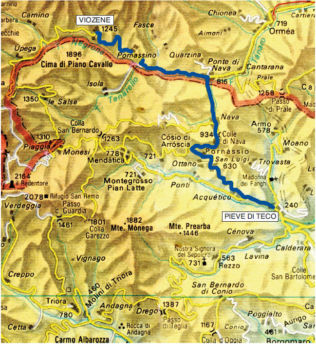
Pieve di Teco - Viozene
Going along the State Road 453 from Albenga, you will arrive near Pieve di Teco (km 22), which can be avoided with the new tunnel route of State Road 28 and can continue towards Colle di Nava while the landscape becomes decidedly alpine.
The wide pass of Colle di Nava (934 m) connects the Upper Arroscia Valley with the Upper Tanaro Valley and gives access to a pleasant plateau surrounded by wooded slopes.
The road runs along it all on its left side and seems to go like into a funnel towards Ponte di Nava (km 40 - 816 m) having on the right the rocky banks of Rocca Ferraira with the appendix of Rocca Slanciata (above, in the center, the small hamlet of Quarzina).
Turning left towards Viozene, the road winds next to the course of the Tanaro river having on the left the imposing rocky walls of Rocca Pizzo, Rocca Rossa and Monte dei Cancelli (1534 m) which break off at the confluence of the Tanarello stream into the Negrone (which from this point takes the name of Tanaro). The opposite side of the valley becomes more interesting, where the Mongioie ridge begins to emerge with the mighty profile of Rocca Garba and the lively cliffs of Cima delle Colme, Pian Comune and Rocce del Manco that fall onto Pian Rosso with bold rocky peaks.
The opposite side of the valley is closed by the dentate, almost straight and long crest of Pian Cavallo.
Reach Viozene with the option of a walking tour to the Mongioie Refuge.


ESCURSION TO PIAN ROSSO
(trekking)
From Viozene (1250 m), go up to Piumini (1270 m), then to Tetti di Pian Rosso (1524 m): a few more steps and you are almost on the edge of the plateau with the Mongioie Refuge (1550 m) in the center in beautiful evidence (time of ascent: almost 1 hour, first on a little road and then on a good path).
The vast plateau with incredible spring and summer flowerings is currently exploited as a pasture, while in past times it was sown with rye and potatoes for the sustenance of the far more numerous villagers.
The panorama offered is of first class, with a detailed view of Viozene below and Pian Cavallo on the opposite side of the valley. To the north you have the close rocky barrier culminating in the Mongioie with, on the right, the Bric Conoia.
In summer, the Mongioie Refuge operates a shuttle service from Viozene to Pian Rosso going up a narrow street of about 2.5 km (also walkable on foot) more monotonous, but easier than the mule track that starts directly from Viozene.
Possible excursion from the Refuge (1550 m) to Vene del Tanaro (1525 m) on a well-marked path (about 1 hour).
From Vene del Tanaro it is possible to climb, passing under the spectacular Rocce del Manco, up to Colla di Carnino (1592 m) and then descend to Carnino (1390 m) in 1 hour and 15 minutes from Vene.
From Carnino, by car, in about 8 km you can return to Viozene.
In case you wanted, from Carnino - returning to the Provincial Road and passing (through the tunnel and protected by two avalanche barriers) the gorge Gola delle Fascette - in about 3 km you could reach Upega, a mountain village with typical well-preserved wooden balconies.
During the summer, since it is impossible to reach Monesi from Mendatica or from Nava, it is possible to ascend the well-known Black Forest from Upega for a few kilometers: near Colletta, next to the Giaireto picnic area, turn right on a dirt road that - through Bosco delle Navette - reaches the former military roadway with natural bottom and regulated traffic which, in an unforgettable journey of forty kilometers between the highest peaks of the Ligurian Alps and extensive panoramas on all the Maritime Alps, arrives to Colle di Tenda Vecchio, where there is asphalt again.
Turning right you can go down to Limone Piemonte; alternatively and more adventurously, turning left and returning to the dirt road you’ll reach the lower Peirafica and Casterino where, back on the asphalt, you can go down the Val Roia to Ventimiglia.


THE MONESI - LIMONE PIEMONTE ROAD
History
The ex military road is known, improperly, as Via del Sale or Via Marenga.
In reality, this is the most spectacular stretch of a series of high ground routes which, starting from the 18th century, served to connect the fortification system built to defend national borders. It also included the sections of Alta Valle Roia and Alta Valle Tanaro, from Authion (at that time in Italian territory) to Colle di Nava.
These roads, almost all theoretically accessible with adequate vehicles (subject to the limitations of local Administrations), cross many mule tracks, which are the true Vie del Sale or Marenche.
These Vie Marenche have very ancient origins and are still accessible today. Our ancestors departed from the coast or from the main centers of the valleys and, through numerous mountain passes, on the back of a mule, carried goods (mainly salt, salted anchovies and oil) towards the Piedmont plain or towards France, returning with loads of flour, eggs and other products.
Each valley had its own itinerary which, at the top, ran along some stretches in common with others. Then it detached and reached, through the routes considered more convenient, the places of the plain object of their trades.
Already after the First World War, but even more after the Second World War, all these itineraries (sometimes apparently illogical from a geographical point of view due to the changing administrative boundaries of the various territories crossed) have been completely abandoned due to the changing of the economic situation.
Over the years, both the exploitation of the forest and the pasture have been reduced to very little; in the meantime, for the exchange of their products, the other (not mountain) places of the territory could benefit both from a new road development and from modern and fast means of transport.
Quite recently, it has been realized that this "obsolete" road network (kept alive, it must be said for the sake of truth, by hunters and by some rare mountaineers), having lost its economic and military value, could be valued for leisure and tourism: this is how paths and mule tracks have started being systematically signed and kept clean.
Later, in an overall development project of the territory, more demanding enterprises were considered and, despite the general limited resources, the section of the former military road Monesi - Limone Piemonte was made accessible in acceptable conditions of safety, albeit with strong limitations for motorized traffic.
With the adoption of two barriers for toll collection (15 euros for cars - 10 euros for motorcycles and four-wheelers), one in Briga Alta (since it is impossible to reach Monesi) in the “Navette” area, and another one in Limone Piemonte in the “Cabanaira” area, the vehicular traffic has been allowed for a maximum of 80 cars and 150 motorcycles per day, from Wednesday to Sunday of every week for the period that generally begins at the end of June and ends on October 15. For the remaining periods of the year, access is inhibited by bars and is available only for pedestrians and bikers.
The repositioning of the access barrier to Bosco delle Navette reduces the route by about 10 km, which however, paradoxically, is more fascinating and pleasant because the approach from the Upega Valley has unique landscape values and eliminates the rough dirt road stretches that from Monesi can be encountered before arriving to the toll barrier.


The path
The access barrier is placed at 1900 m in the Bosco delle Navette area (so called because the timber taken from the wood was used mainly for the construction of boats and ships).
After the steep climb undertaken to reach the barrier, the roadway winds in plan having on the right the edges of the forest and on the left the grassy slopes that lead to Colla Rossa.
After about 2 km you’ll arrive to Poggio Lagone (m 1898) where, below, is a beautiful pond. From there, a well-marked path descends to Upega in less than two hours.
It is also possible to go up the path to Colla Rossa (2175 m) in about an hour, but - although it is a well-marked path - it is recommended only for those who are mountain experts because the route, although easy, is not always obvious. From the wide pass there is a beautiful view of Monte Bertrand (2482 m).
The road now runs for several kilometers in the woods which, especially in autumn, takes on marvelous colors, while the roadway is covered with a soft carpet of larch needles: then, less than 1 km from Selle Vecchie Pass (altitude 2050 m approximately), the vegetation thins out and the view opens down towards the imposing forest just crossed with a view on the deep furrow created by Rio Nivorina and on the houses of Upega that can be glimpsed in the valley bottom.
Imposing is the view on Cima di Pertegà, whose sides are engraved on the right by the former military roadway directed to Colle dei Signori.
At the important pass meet the routes of the eastern side of the Upper Valle Roia (now French), through Valloni di Morignolo (La Brigue) and du Bachialon (Tende).
At the pass there is the possibility of parking for some cars.


EXCURSIONS FROM COLLE SELLE VECCHIE
Excursion 1: the climb to Monte Bertrand
(trekking)
Normally, the excursion is undertaken starting from Upega (1200 m difference in altitude) or from Poggio Lagone (with 600 m difference in altitude), to go up to Colla Rossa (2179 m) and enter the splendid old upland mule track. These trails are well marked, but they could be excessive for those who are not used to mountain practice.
We therefore propose the ascent through the north side (400 m difference in altitude), all on a wide mule track and with a regular climb up to the summit, as it appears evident in the photo taken from Cima di Pertegà (m 2404).
The mule track, departing from Colle Selle Vecchie (2097 m), climbs the slope visible at the base of the cross until it reaches Colle del Vescovo (2182 m) on the ridge. There, bending to the left, it runs along the entire ridge up to Cima di Velega (2384 m), where it runs flat for a few hundred meters before reaching the maximum altitude of 2400 m at the junction to the summit of Monte Bertrand (2484 m). Taking to the right of the mule track, on an easy path, in a short time you’ll reach the massive summit cross.
Total time: 1 hour and 30’ - 1 hour and 45', but even less. Everything depends on your legs and your age ... it is anyway 400 meters of difference in altitude to climb on regular ground.
From the summit, the view of the Maritime Alps is magnificent.
Far to the west, from the left is the regular Cima Scandail (2454 m), the two close cusps of Capelet Superiore (m 2637) and of Cima del Diavolo (m 2685), Monte Bego (m 2872), the Grand Capelet (2935 m) and the nearby Rocce Muffié, then the Tre Cime del Basto emerging from a clear patch of rubble, then the Cimienais (2918 m), the sharp Lusiera (2907 m), the massive Clapier (3045 m), Monte Gelas (m 3143), Cima alla Maledia (m 3061), and finally, next to the cross, to the left the Argentera (m 3297) and to the right Monte Matto (m 3088).
Closer, towards the south, the eye falls on the wide and barren depression of Colla Rossa (2179 m), where it is possible to go down directly on traces of path (absolutely not recommended to those who are not mountain experts) or following the long path of the beautiful mule track that you left at the junction to the summit.
Beyond Colla Rossa, this high ground mule track (an ancient Via del Sale) with a fantastic trail, climbs (2300 m) almost to the summit of Cima Missun (2356 m) to descend, with almost always a ridge path, to Colla Cravirola (2259 m) - in the photo with the height node 2273 and Punta Farenga (2211 m) - and then with a large semicircle on the side of Cima Ventosa (2136 m), to the nearby Passo del Tanarello (2036 m).
Keeping a car at Passo del Tanarello and another one at Colle Selle Vecchie you can avoid a return on foot: it's not an impossible thing, but it's anyway a 4/5 hour commitment.


Returning on Monte Bertrand, the view to the north is just as stimulating.
Nearby, you have the easy ascent route with the ridge line that descends to Cima di Velega (2384 m), where the ridge bends sharply to the left to Cima del Vescovo (2284 m).
Further on, from the left, Cima del Cuni (2260 m) with the distant Monviso that seems to touch the clouds, Colle della Boaria (2102 m) where the road passes (as you will see later), Cima della Fascia (2495 m), Passo di Colla Piana (2219 m), with the dark outline of Bric Costa Rossa (2404 m) behind, then Monte delle Carsene (2383 m), the "dentino" of Castello delle Aquile (2513 m), Cima dell'Arnusso (m 2526) and Punta Marguareis (m 2651) with Cima di Pertega in front (m 2404) with the white line of the road that goes up to Passo di Framargal.
A little further to the right of Punta Marguareis, Colle dei Torinesi (2450 m), Cima Pareto (2538 m), Cima Bozano (2564 m), Cima Palù (2538 m), Punta Emma (2527 m) and the dentate Rocche Bisté which descend on the wide Colle del Pas (2342 m).
Then, Cima Pian Balaur (2604 m), Cima delle Saline (2612 m), the dark Cima Seirasso (2436 m) and the wide depression leading to Colle Brignole-Seirasso (2329 m) followed by Cima della Brigola (m 2472). Near, from the left, the roadway that cuts across the slope of Cima del Pertegà up to the Pass of Framargal (m 2179) and the crest of the Ferà (m 2235).
Below the grassland, Bosco delle Navette, Vallone di Upega with at the bottom the white dots of the houses of Upega (1300 m), beyond which you can sense the deep Gola delle Fascette, while on the right rises Cima di Cantalupo (m 1890), Quota 1906 (strangely without a name despite being the highest altitude on the ridge), Cima di Pian Cavallo (m 1896) and Monte Cimone (m 1831) with its unsightly repeater clearly visible when climbing from Ponte di Nava towards Viozene.
To the left of Upega, to delimit the Vallone, are Cima Caplet (m 1956), the Ferà (2235 m) and the wide depression of the Framargal Pass (m 2179) just below the roadway.
Above, half-hidden by the clouds, the Mongioie (2630 m), the dentate Bric Conoia (2531 m) and the Pizzo d'Ormea (2476 m).
Return: through the same path (about 1 hour).


Excursion 2: from Selle Vecchie to Colle dei Signori through Via del Sale
(trekking)
From Selle Vecchie, instead of proceeding on the former military road, it is possible to easily reach Colle dei Signori through the ancient Via del Sale, which we previously described, up to Passo del Tanarello.
Still from Colle Selle Vecchie, a steep mule track descends the narrow Vallon de Bachialon (on the left), enters the Vallon de Refrei and reaches the Grange de La Pia (919 m) where, becoming a narrow carriage road, it reaches Tenda.
Far away, from the left to close the Vallon de Refrei, is the massive Cime de Pepin (m 2344).
Closer, after a rocky spike almost on the same line, Cima di Seneca (2138 m), Cime de Malabergue (2188 m) and Cima del Cuni (2259 m).
Looking further to the right, the slope from Cima di Seneca rises to the rocky cusp of Cima di Capoves (2260 m), while the dark top of Cima della Fascia emerges from a pile of whitish limestone rocks.
After a moderately steep initial stretch on which you can gain a hundred meters of altitude, the mule-track draws a broad almost flat semicircle, passing under some characteristic rocks near Colle Capoves, just below Cima Capoves (2260 m), where it returns to the Italian side and descends beautifully over the long summit of Cima Gallina (2400 m) and, further to the left, over the Marguareis, finally entering the former military road a few dozen meters from Colle.
Once at the beginning of the semicircle, turning right and heading up on the steep slope, it is possible to go through easy tracks up to Cima di Pertegà (m 2404) and follow the flat ridge from the simple cross to the summit cairn.
On the left are the curious shapes of the Ferà (2235 m) and the Rocca del Ferà (2221 m).
To the north is a beautiful view of the nearby rocks and the Cima di Capoves (2260 m) with the sides of the ridge marked on the right by the former military roadway that reaches Colle dei Signori.
The return can be made either by the same route or along the approximately 5 km that separate Colle Selle Vecchie from Colle dei Signori. The route along the ancient mule track is considerably shorter.
The climb to Cima di Pertegà (an additional 200 m of difference in altitude) is simple, but since these are trails identifiable in plain sight on the easy slope it is absolutely not advisable in case of poor visibility.
Along the old mule track, the outward / return journey can be made in about 2 hours (calculate an additional 75 minutes for the climb to Cima di Pertegà).
Going uphill from Colle Selle Vecchie, you’ll get - in about 2.5 km – to 2200 m above the Framargal Pass (2179 m) with the thin trail of the ridge path leading to Ferà (2235 m) followed by the “teeth” of Rocca Ferà (2221 m); to the right is the dark ridge of Pian Cavallo and to the left the Mongioie.
The road, still on the side of Cima di Pertegà, reaches an altitude of about 2265 m, the maximum height of the entire route. Then it begins to descend rapidly towards Colle dei Signori (2112 m - 12 km from the barrier) with Cima di Capoves clearly visible.
On the left you can see the trail of the previously described Via del Sale which merges into the carriageway. Below, Vallone dei Maestri develops with the new and the old Rifugio Don Barbera and the bold outline of the Ferà (2235 m).
The curious name of the Vallone is due to the fact that in the Middle Ages, during the summer, transhumance was practiced with permanent transfer to the mountains of the whole family, including children, to look after the cattle of the master.
The lords of the place, in order not to let the children of their subjects miss their teaching, paid a teacher (usually a cleric), to attend the various pastures and give adequate education to the children.


Beyond Colle dei Signori, you’ll enter a very large basin surrounded by a crown of mountains that change the scenery at every curve; rocky stretches, which sometimes take bizarre shapes due to ancient glaciations and recent atmospheric agents (the wind but above all the rain carve and even dissolve this type of carbonate rock), alternate extensive green spaces that contrast with the whiteness of the rocks and the blue of the sky.
What looks like a squat rock, when you turn the corner looks like a sharp tip and at a certain point, if there was no road as a precise point of reference, you would no longer be able to understand where you are going.
On the right you have Cima di Gallina (m 2400) and then Punta Marguareis (m 2651). On the left, immediately after the hill, a path branches off which - after briefly crossing the small Piano Scevolai - descends steeply to the Vacherie de Malabergue in the Vallone di Refrei.
The valley is delimited at the top by the squat rocky Castel Frippi (m 2256) and by Monte delle Carsene (m 2383). After passing a rocky ridge, you can go down quickly and smoothly to the vast Piano degli Ambrogi (2080 m) dominated by the imposing Castel Frippi and by Castel Scevolai.
Drawing a large semicircle on the edge of the basin, you’ll reach with a light ascent the restructured Gias of Pian degli Ambrogi (2100 m), while the roadway creeps into the depression between the two "castles" going up to Colle di Malaberga (2200 m) to reach another basin that you can go around again to the right, slightly losing height.
Shortly before passing to the opposite side of the valley with the roadway that marks the entire western slope of Testa Ciaudon (2384 m), the GTA path (Grande Traversata delle Alpi) branches off at a height of about 2150 meters, extensively signalled, directed to the Upper Valley of Pesio and then of Ellero.
Meanwhile, the roadway reaches slowly the end of the karst area, it further loses height by a few tens of meters and touches Colle della Boaria (2102 m - 8 km from Colle dei Signori - 20 km from the park barrier) where there are numerous remains of military artifacts.
On the right, very close, is the grassy Cima di Malaberga. Far away, surrounded by clouds, is the Marguareis, which from this perspective takes on the appearance of a sleeping face.
Colle della Boaria connects the head of Val Roia, now in French territory, with Val Vermenagna and the ski center of Limone Piemonte.


Excursion 3: Colle alla Boaria ring
(trekking)
Starting from Colle della Boaria it is possible to take a panoramic excursion by walking along the GTA route up to Colle della Perla and from there back to Colle della Boaria along the former military road.
The route, according to the signposts, would last 1 hour, but we - being calm city people - think we could do it in 1 hour and 30 / 1 hour and 45 minutes, nothing that would prevents us from passing the barrier placed at Cabanaira before its closure.
At the hill (2102 m), leave the car and start to climb to the left along beautiful grassy slopes towards Cima del Cuni. The view is beautiful and detailed (from an altitude of about 2140 meters): at the bottom is Colle della Boaria with the ruins of the barracks and the beautiful pastures of the area that goes up to Colla Piana with at the base the road to Colle dei Signori.
At the center are Testa Ciaudon (2386 m), and Punta San Salvatore (2415 m) with the beautiful rocky ridge that descends to Testa San Salvatore (2163 m) while Cima della Fascia (2495 m ), bold from this perspective, emerges above everything. Further to the right are the pastures of Cima di Malaberga (2188 m) with the characteristic profile of the Marguareis on the left.
The trail continues to climb up to an altitude of 2200 meters with a beautiful view on the last rocks of Cima del Cuni and with a view down to Colle della Perla (2083 m), also reached by the roadway that you will later travel to return to Colle della Boaria.
From Colle della Perla, the GTA route branches off to the left, which goes up the sides of Cima del Becco (2300 m) and which, with a long and splendid ridge path, descends to Forte Centrale and then to Colle di Tenda.
To the right of Colle extend the vast pastures of Vallone San Giovanni (Val Vermenagna- Limone Piemonte) where the roadway, with a very wide semicircle at the base of the massive Cima di Pepino (m 2344), leads to Colletto Campanino (m 2142).
After reaching Colle della Perla (2083 m), turning right, go along the roadway towards Passo della Boaria going up the opposite side of Cima del Cuni to an altitude of 2180 meters, where the road -with a couple of spectacular hairpin turns- brings you back to Colle della Boaria, where you can retrieve the car.
Once you have reached Colle della Perla, this time by car, travel along the entire northern edge of the basin at the foot of the massive Cima Pepino (already observed on the hike around Cima del Cuni).
Below, look at some ponds (sometimes dry at the end of the season). In front of you, unfolds the road that climbs Colletto Campanino (m 2142) at the base of the bold bulk of the homonymous Bric (m 2262) near Colletto; one of the ponds previously observed takes on the perfect shape of a heart.
Far away, in the center of the plateau, stands the green Bric della Perla (2183 m), with the line of the road that cuts the slopes of Cuni on the right and, in contact with the clouds, the Marguareis.
You will now begin to descend into Vallone Cabanaira marked by some ski lifts and near the arrival station of the Cabanaira (around 1950 m) where is the end of the regulated area of the road; the rocky north face of Cima del Becco Rosso (2214 m), touched by the ridge path of the GTA, seems to represent the last difficulty of the road.
In fact, at about 1800 meters, passing under the ruins of the barracks of the Central Fort, it enters the Colle di Tenda road just a bit downstream of the pass (30 km from Navette).
The analytical description of the Monesi - Limone ends here: whoever has enough of dirt and mountain roads can go down to Limonetto and then to the tunnel of Tenda to return to the place of departure. On the other hand, if you have a car that is suitable for adventure (i.e. with a rather high floor), once you have reached the road to (old) Colle di Tenda you can turn left and reach the pass at an altitude of 1871 meters by dirt road.
The road for the descent of the hill on the French side is closed; however, on the right, a dirt road with a prevalent trend from north-east to south-west leads first to Forte Margherita (m 1842), then passes to the base of the imposing Rocca dell'Abisso, goes up again to Bassa di Peyrafica (m 2028) and, having become paved in the last few kilometers, reaches Casterino (1540 m): from there, along the Val Roia, in about fifty kilometers you can reach Ventimiglia.

