
Altitude: 106 m a.s.l.
Area: 12 sq km
Distance from Imperia: 50 km
Inhabitants: in 1881: 1171 - in 2017: 698
Patron Saint Day: July 22nd - Santa Maria Maddalena
Information: Municipality phone 0184 208127
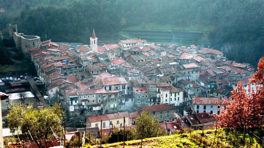
Located at the confluence of the Nervia and Merdanzo torrents, Isolabona developed at the foot of the Doria castle (in the first centuries after the year 1000 it was known as "Castellum"); the village has always been subject to Dolceacqua of which it has followed the events.

Visit of the town
Parked the car on the road, enter the village through the Romanesque Ponte del Molino with a single arch and a small aedicule, from which, after passing the vaults, you’ll enter the main street of the village.
In the widening there is on the left a beautiful medieval fountain with an octagonal stone basin and a central column surmounted by a marble basin sculpted with water-dispensing masks; on the cover of the basin is engraved the date 1486.
Going up the central street, reach the parish church of Santa Maria Maddalena, originally from the fifteenth century but later extensively remodeled in Baroque style and then rebuilt again in 1836.
In the square on the right, the premises of the Centro Anziani have been created under the wide Municipal Loggia with large Gothic stone arches supported by low columns, a loggia that preserves the stone step with the remains of the original cobblestone.
In front of it at number 14 there is a beautiful carved door and at the bottom of the square on the right there are archaic houses, with a roof terrace whose mullioned window has been deprived of the column.
To the left of the church stands the Baroque oratory of the Holy Cross (Santa Croce); take Via Molino on its left, passing a window-door under the second vault and an aedicule in the next widening; passed the vault under the aedicule, get out of the inhabited area to reach, about thirty meters after, the massive walls of the Doria Castle.
On this side a secondary door opens; continue crossing the asphalted road, and immediately after take to the left the flight of steps that leads to the main entrance.
Originally the construction consisted of the only quadrangular tower in squared ashlars, built a little later than the year one Thousand, still well preserved even if truncated at the top, with narrow and very high loopholes, three at the top and two at the bottom on each side.
Around the 13th century, near the tower, the Dorias built their hexagonal-shaped castle in sandstone, of which today remain the perimeter walls with large windows.
Opposite you have the entrance door, surmounted on both sides by large splits through which were maneuvered the chains of the drawbridge, which rested on the ground on the two stone brackets on the sides of the gate; the recent restorations have somehow reconstructed the square in front of it.
Moving to the right near the cross you can see below you the overhang that made this side of the fortress impregnable, and the mighty battlements of the castle that dominates the village.
Returning to the church, go right on Via Guiglia and continue under the arches keeping the left and arriving, past the vault of Vicolo Scuro, to the intersection whose street to the right ends with the aedicule of the Virgin; go to the left, cross the central street paved with porphyry cubes and continue straight on Via Gioberti.
At the end of the street, take the left on Via Gelso and then the left again, passing by the archaic river-pebble house with a fine thin stone arch to support the staircase.
Taking a look under the vault on the left, continue straight ahead a little further on and, under the arch that crosses the street, you’ll see a stone ball about thirty centimeters in diameter embedded at the top left, perhaps an archaic cannonball placed there in memory of an assault suffered.
Immediately afterwards go to the left under the high cross vault, where open a carved door on the right and then at number 2 a stone portal with a roof, melancholy memories of a past prosperity; at the intersection with Via Gioberti turn right, cross the road continuing till the end of Via Orsini, with other rustic houses in bare river stones, and having reached the end of the street take Via Ruffini on the left to reach the widening with a fountain from which you can go back to the car.
Going up the Provincial Road shortly after you’ll reach the cemetery, where there is the Romanesque church of Santa Maria built in the 12th century.
The church, very bare, has three naves divided by two low pillars connected by round arches; the cover is barrel-shaped.
In the lunette above the ancient entrance there is the fresco "Baptism of Christ"; another fresco of the Baptist is in the square on the facade, surmounted by an oval oculus.
On the right wall there are two slits and two rectangular windows.
A little further on stands the small sanctuary of Madonna delle Grazie on the side of the Provincial Road, whose portico was rebuilt in the seventeenth century on the original chapel frescoed in the previous century by an anonymous northern Italian painter.
The interior of the church is entirely decorated with frescoes: on the first cross vault is depicted on one side the Virgin with the Kings of Israel, while the slice on the right shows the tree of Jesse (genealogical tree of Jesus Christ); the other vaults and the walls are decorated with frescoes with stories from the life of Mary.
Continuing to climb along the Provincial Road, just before Pigna there is the junction from which, going left, you can take a splendid mountain excursion to the Gouta Gorge and to Margheria dei Boschi, at the border with France.
Continuing instead along the Nervia in two kilometers you’ll arrive to Pigna.