
Altitude: 66 m a.s.l.
Area: 4 sq km
Distance from Imperia: 12 km
Inhabitants: in 1881: 951 - in 2017: 1160
Patron Saint Day: June 24th - San Giovanni
Information: Municipality phone 0183 406462
The Roman conquest took place in 181 BC. The favourable strategic position of the place induced the Romans to establish here a “mansion” that took, it is not known why, the name of Servo ("Servant"), from which the current "Cervo" derived.
In the years following the Longobard conquest of Liguria, carried out by King Rotari in 643, the few surviving inhabitants fled to the heights, where they reorganized into an easily defensible fortified complex, which would have formed the first nucleus of the castrum.
Around the 12th century the village passed as a fief to the Marquises of Clavesana who built their castle there; in 1204 the inhabitants of Cervo emancipated themselves by force from Diano Castello and elected their Consuls under the protection of Genoa, which in 1330 assigned the town in fief to the Knights of Rhodes, who sold it the following year to the Marquis Lazzaro Doria.
In 1336 the marquis Enrico Del Carretto arrived and attacked Cervo and conquered it for almost fifty years, until (1384) he was defeated and taken as a prisoner by Genoa.
Since then Cervo remained definitively under Genoa (in the past aka “la Superba”, i.e. “the Superb city”), to which it would always be faithful.
On the sea, the people of Cervo have written so much of their history; they also participated, with "... two helmsmen, twenty soldiers and crossbowmen, and forty rowers" in the naval battle of the Meloria in which in 1284 Genoa crushed the rival Republic of Pisa.
In addition to being sailors, many inhabitants of Cervo specialized in coral fishing, which in the fifteenth century pushed the "coralline" boats from Cervo to the Tunisian coasts and in later centuries to the more profitable banks of Corsica and Sardinia.
Even though the income of the coral caught could be considered conspicuous, given the legislation of that time, that required the delivery of the catch to Genoa, Cervo never developed a possible goldsmith industry.


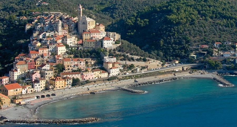
Visit of the town
The medieval village can be reached by car, leaving Via Aurelia at the intersection with Via Solitario delle Alpi, which in less than a kilometer leads to the pedestrianized square of Piazza Castello.
Founded on the bare rock, there stands the most significant building of the village, the castle in fact, which summarizes two millennia of history.
From Piazza Castello, on the west side of the massive construction, it’s clearly visible the mighty original square tower, built with well squared blocks; around the XII century a fortress was built next to it which incorporated it using it as a cistern.
At the beginning of the seventeenth century, when the Turkish Barbarian danger was drastically reduced thanks to the battle of Lepanto (1571), the construction, in addition to its military use, started having a religious one: gutted from the roof to the floor, it was used as an oratory for the members of the confraternity of Santa Caterina, the saint of whom it still preserves the seventeenth-century fresco on the vault of the upper hall.
After the inauguration (1736) of the majestic church of San Giovanni, this construction returnd to an exclusively civil use, destined to be the new and more functional seat of the ancient hospital that operated in Cervo since 1330, when it was founded there by the Knights of Rhodes in the very short period of their Cervo fief; it finally underwent the last renovation which restructured it internally on two floors.
Summarily restored in 1980, it is now the seat of the tourist information office and of the museum center which includes the permanent exhibition "women of Liguria" and the rich Ethnographic Museum of Western Liguria that reconstructs phases of domestic, agricultural and maritime life of the last century; numerous tools and furnishings of the time decorate the various rooms, in which life-size mannequins dressed in the costumes of that period recreate a suggestive cross section of the life then lived.
The north wall of the castle is continued on both sides by the massive walls of the sixteenth century that bend on both sides towards the sea to offer, to the east and to the west, the accesses to the town respectively through Porta Santa Caterina and "u garbu", to then go down, interspersed with defensive towers, up to Porta Canarda protected by the Bastion, to the east, and to Porta Marina, defended by the tower incorporated into a house, to the west; in later centuries, to gradually accommodate the new houses, the circle of walls would repeatedly expand into concentric semicircles towards the sea.
Leaving the castle, go left down the short stairway to observe Porta Santa Caterina and the circle of sixteenth-century walls to the east: then retrace your steps and, after crossing the square again, take the right under the vault.
After a short stretch inside the walls, on which a harquebus slit opens at the top right, come out through Varco Bondai on the open space with a view of the Dianese Gulf; from there you can see the walls continuing uninterrupted, fortified by a tower, to surround the town on the entire west side. The church of San Giorgio di Cappadocia, that you see below on a hillock, revealed in its foundations ruins that support the hypothesis of its original construction on a pagan temple of circular plan; abandoned in the fifteenth century because it was too exposed to the attacks of the barbarian Turks, it was given in the seventeenth century to the Augustinian friars who rebuilt it in a vaguely Moorish style, dedicating it to San Nicola da Tolentino and also building nearby a convent which has now disappeared.
Within the walls, the steep descent of Via Romana follows the original Via Julia Augusta: here the development of the town began two thousand years ago.
Walk about thirty meters and climb the flight of steps to the left and then turn immediately to the right between two gardens; from there to the east there are numerous streets running parallel to the Roman road that all connect the castle, the fulcrum of civil life, to the oratory (then a church), the fulcrum of religious life.
To enter into the heart of medieval Cervo, venture into the dusky Vico delle Rose with its pointed portals in cut stones.
One meter and a half wide and mostly covered by the builders of the time in a desperate search for space, the alley immediately runs inside the first circle of walls built before the year one Thousand, in which two small square windows open to the west to offer unexpected bright panoramic views of the Diano area; at the end of the alley you’ll be facing the facade of the oratory of Santa Caterina, built around the year 1100 at the southernmost point of the village.
A classic example of a genuine Romanesque structure, the building had originally a Latin cross plan with two side chapels.
The two side walls are perforated each with three high splayed single-light windows; the bare portal, surmounted by a high splayed oculus, has at the sides two small columns without bases of a much earlier age with a guardian-wizard carved in the capital on the right.
Moving a few steps to the right you can see the elegant black stone carved portal of the Salineri chapel; adjacent to the chapel there is, almost unrecognizable because it was incorporated into the building, the quadrangular tower with an ogival arched stone portal that defended the underlying (in correspondence of the archivolt) Porta Marina, the oldest access to the town from the sea through the first circle of town walls.
The homologous chapel on the opposite side of the oratory was demolished (Baroque traces can still be seen on the external wall) in the eighteenth century to create the alley that leads to the side entrance, at the foot of the seventeenth-century bell tower.
The interior is of proportions based on the square module: the plan is made up of three perfect squares and the section in elevation is also a square.
The building, with a single nave, was originally the parish church of the village dedicated to San Giovanni; in the sixteenth century it was consecrated to San Giorgio, of whom it preserves a fresco.
Modified in the Baroque period, in 1965 it was restored to its original bare stones with the recovery of the trussed roof and the elimination of Baroque superstructures and plasters, left only in the apse of problematic reconstruction and on the right wall, which preserves anonymous frescoes of the fifteenth century.
Leaving the oratory, instead of being attracted by the glimpse of the parochial Baroque church that dominates you, go down on the right and immediately after, in correspondence of the slate portal of Palazzo dei Vento under the bastions of the sixteenth-century walls, go right again; at the bottom, under the vault on the right where the oldest Porta Marina once stood, you can go up a few steps to observe on the right, intact in its lower part, the tower that defended it and the eighteenth-century opposite "Palazzo del pulìn" ("Palace of the chick"); from there go down to the widening with a sea view and take the right, arriving under the articulated archivolt with a fountain in which ends up Via Romana, which is the road you have left at the Bondai gateway.
The original route of Via Augusta continued to descend along the flight of steps, passing alongside the seventeenth-century Palazzo Morchio, the current municipal seat, to then exit the walled town through the eighteenth-century Porta Bondai.
From there retrace your steps and, once you have reached the widening with large ficuses, continue under the arcade of the café-restaurant at the end of which take on the right the short descent that leads you to the Bastione, a sixteenth-century fortress recently restored and used for exhibitions and events, from which the artillery could cover the entire stretch of sea in front of the town.
Leaving the town through the nearby Porta Canarda, you can see the circle of walls that goes up to Porta Santa Caterina to join the castle; to the west the walls continued up to Porta Marina, from where they went up to seamlessly close the defensive belt.
Back by thirty meters, take Via Matteotti on the right; after another fifty meters to the east, go left up the stairway of Via 11 Febbraio which brings you to the churchyard of the imposing church of San Giovanni Battista, begun in 1686 and finished in 1734; the bell tower is of 1778.
The church, designed by the architect Marvaldi of Candeasco, dominates a wide stretch of sea with a particularly suggestive scenographic effect; it is considered the most important Baroque monument in western Liguria.
The façade is convex, decorated in soft green, yellow and pink colors; the interior, with a single nave, preserves a seventeenth-century crucifix by Anton Maria Maragliano, the marble pulpit with the sixteenth-century bas-relief "La Pietà", the fifteenth-century marble cabinet for the Holy Oil and, in a niche on the right, the seventeenth-century wooden group "Family of San Giovanni" by Marcantonio Poggio.
Leaving the church, climb the steps upstream in correspondence of the aedicule dedicated to the Virgin, and take Via Grimaldi Salineri.
Along the street, archaic stone portals with ogival arches succeed monolithic architraves, alternated by centuries-old vine plants that offer their bunches twenty meters higher up on the roof terraces; at number 22-24 were located the prisons of the village (the street is still known today as "Caruggiu da galea") of which remain the façade in squared stones and the stone shelves to support the disappeared machicolations.
In the village there are numerous manor houses from the seventeenth and eighteenth centuries.
Back to the car, going down Via Solitario delle Alpi, at the junction to Poggio go right and, at the top of the hill, take on foot the path on the right near the large cylindrical water cistern; after two hundred meters there is the rustic church of San Giuseppe with a porch and stone seats, near the ruins of Borgata Villavé.