
Altitude: 715 m a.s.l.
Area: 16 sq km
Distance from Imperia: 37 km
Inhabitants: in 1881: 987 - in 2017: 165
Patron Saint Day: September 2nd - Saint Anthony the martyr
Information: Municipality phone 0184 409017
The name of Carpasio is thought to derive from the peace treaty ("Cara pax") which was stipulated there between the indigenous Epanteri Ligurians and the Romans.
A different interpretation of the toponym could instead refer to the terms “Car” and “Paxe”, with the term “Car” meant not as "stone" according to the common meaning, but as "stone" par excellence, i.e. "foundation stone", placed by a group of Celt-Ligurians led by a leader, named “Car”. In the name of the chief, as a true eponym of the town, a stone village, i.e. a “pagus”, was therefore founded, which in their language they called “paxe”; hence from these terms would have derived Carpaxe.
Formerly belonging to the Arduinic district and subject to the Clavesanas, Carpasio passed to the Guerra-Lascaris and then, conquered by Genoa, in 1261 it was given in fiefdom to a Doria del Maro whose descendant Giò Girolamo sold it in 1587 to the Savoys, under whose dominion it remained permanently.
In 1423 it obtained the approval of the Statute, of which it keeps the original in the municipal archive.
In the last hundred years the village has lost four-fifths of its inhabitants and is scarred everywhere by the traces of this process of abandonment which now seems irreversible.


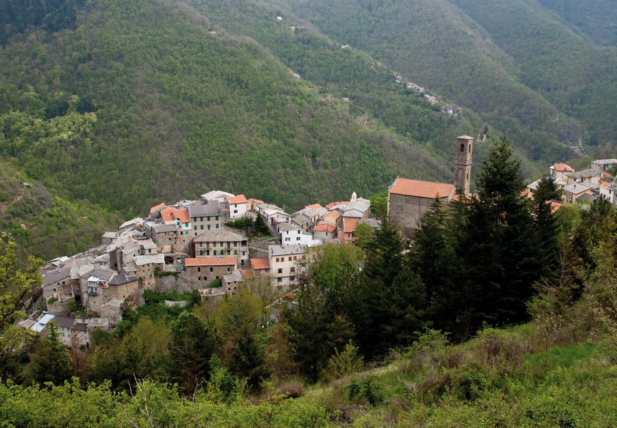
Visit of the town
Arriving to the village, park in the widening on the right where, at the corner of the small municipal building, the layout of the village is shown and, going up the stairs on the left, reach the widening where the Baroque oratory of Annunziata rises in front of the parish church: the façade is enriched by a plaque carved with an "Annunciation" and also the bell tower's single-light window is decorated with a carved stone.
Next to it is the church of Sant'Antonino, martyred in Adamea in Syria; the building was erected in the early fifteenth century, then completely rebuilt in Baroque style in 1697, renovated in 1729 and then restored again in 1889 after the serious damages caused by the earthquake occurred two years before.
Of the original building remain the Romanesque bell tower and, next to the left side door, chunks of columns, two capitals (one of which with a guardian wizard), and a monolith carved with floral volutes that was a jamb of the portal.
Opposite there is a rustic votive aedicule of 1822, with a slate slab painted with the image of a clumsy hunter who pierced his hand with the muzzle of the muzzle-loading rifle; another aedicule, similarly made with a slate slab painted with the Virgin and San Giovanni Battista, is at the beginning of the churchyard to the left of those who go up.
Go down to the right of the oratory and after reaching the asphalted road walk a short stretch on the left up to the widening on which the wash-house rises, faced by abandoned houses that testify the involution of the village.
Once back, go down along the cobblestone street with bricks in the center, passing the small fountain faced by a decorated architrave, beyond which opens the window-door of an old shop, noticing the other carved lintel on the left on Via G. Bosco.
Going down to the left under the archivolt of Via Trento you’ll find, leaning against the wall, a monolith sculpted as a press base; a little further, on the left, above the stone bench, there is a small aedicule faced by a simple portal in black stone.
Go back to the right under the vaults of Via Rodi and upon reaching the fountain take the left and then the right following the brick paving, always proceeding under the archivolts.
After the widening, on the left there is a black stone architrave reused as a bench, and another carved architrave yet now worn out is above the door located at the bottom on the left; in the house next door there is an effective curious solution to the problem of drainage of roof eaves, which emerges onto the alley after running concealed in the masonry of the balustrade.
A little back, go up to the left taking then the right; then follow again the brick paving going up to the left up to the widening with greenery out of the built-up area, from which, following the bricks on the ground, you’ll go back to the left to take the car.
Driven a few hundred meters along the Provincial Road, leave the car on the roadside before the sharp bend on the right and take the steep cobbled ramp up on the left.
After one hundred meters you’ll find the small church of Sant'Antonio, with a rustic "ciappe" roof; proceeding ahead, pass at the feet of the inhabited area and, continuing on the grassy path, you’ll reach in five hundred meters the fifteenth-century church of San Giovanni called "of the Gentiles".
The portal, preceded by a portico with seats and pillars, is in smooth stone, with a deteriorated fresco of the "Baptism of Christ" surmounted by a plaque carved in a Trigram between colored oak leaves; the interior has a paved floor and a modest Baroque altar.
Two kilometers from the village stands the seventeenth-century Sanctuary of the Nativity of Mary, called of "Madona de Ciazina", surrounded by the woods; in the Costa hamlet, which can be reached from the detour that branches off to the left of those who go down, less than one kilometer from Carpasio, a building houses the Resistance Museum which preserves artifacts and documents of the partisan struggle.
From Carpasio a beautiful mountain excursion can be made continuing up to San Bernardo di Conio; from there to Colle San Bartolomeo, and to Rezzo, or through Passo di Teglia and Triora.
Returning from Carpasio to Montalto, continuing to go up along the main route, you can then take the short detour on the right that leads to Glori, a small village in a position dominating the valley now inhabited by no more than thirty people.
Leave the car at the beginning of the village, go down the ramp on the right and arrive to the tiny paved square on which stands the church of the Nativity of Mary.
Under the front vault there is a black stone bench, engraved with the naive drawings of the hermit who later withdrew into Tana dell'Incanto where he died when he was over ninety years old.
Beyond the vault you’ll find the oratory of Sant'Antonio Abate of 1632, with the figure of the saint carved into the oval of the architrave; under the oratory there is the cistern that supplies water to the whole town.
Returning to the Provincial Road, just before reaching Molini di Triora, turn right on the detour that leads to Andagna, observing on the right the defense tower against Saracenic incursions suggestively isolated on a rock in the middle of the woods.
After parking the car at the beginning of the town, take Via IV Novembre which, past on the left the beautiful aedicule with a mutilated plaque of 1597 carved in a Trigram with the letters M b, takes you to the old parish church of San Martino, now abandoned and unsafe among secular horse chestnuts; here also stood the Benedictine convent now disappeared.
The church square in clay is accessed through an arch in tuff supported by two columns with capitals; the portal of the church has the lintel carved in a Trigram between two flowers and jambs decorated with a floral motif.
Taking on the right of the church the ramp that passes under the vault, you’ll get to the large churchyard of the parish church of the Annunciation which preserves in front of the portal two chunks of pillars of the original construction; another column chunk is at the beginning of the square.
The black stone portal is decorated in the center with an angel's head surmounted by a rich aedicule with a statue of the Virgin; the jambs, carved at the bottom with floral motifs, are then worked in semi-columns.
Inside, the glass urn containing the remains and the ampulla with the blood of Santa Clementina, martyred under Diocletian, is kept in the left apse; the relic was taken from the catacombs of San Lorenzo and transferred here by Pope Pius VI in 1789.
On the right wall there is a sixteenth-century "Annunciation" that a very thick grating makes unreachable both to the hands of thieves and to the sight of visitors.
Under the vault that faces the church there are two portals, of which the first one, dated 1644, belonged to the now extinct Rossi family; the second one, of the Barrilari family, dates back to 1640 and has carved in the surviving jamb a worn-out guardian-wizard into a lozenge; the architrave is carved in a Trigram with a rosette on each side.
Up the ramp to the left of the Municipal Loggia take the right; passing a smooth stone portal on the right, with a bench, continue under the archway reaching the crossroads marked by the aedicule with a fountain; from there on the right you’ll reach the chapel of San Faustino.
Going up Via Costa instead you’ll see on the left the use of "ciappe" pierced to hold the poles of a garden, and in the next house a sundial; continuing, you’ll find the now abandoned chapel that concludes the inhabited area.
Back to the church square, go along its right side and, past the two smooth stone portals, return to the car on which, leaving the town, you’ll turn left following the road sign to Rezzo.
After about a kilometer past the already seen Tower of Andagna, continue surrounded by a beautiful mountain landscape.
After four kilometers, in the Drego area, you’ll come across the remains of a Roman camp, and after another four kilometers you’ll arrive to Passo Teglia at a height of four hundred meters, where you’ll cross the Via Marenca mule track, a millennial internal route.
After leaving the car you can walk along it to the left towards Passo della Mezzaluna; in the area are chamois, marmots and even a couple of golden eagles that you might meet with a little luck.
After about forty minutes of flat walk on a highly panoramic ridge you’ll come to the depression of "Sotto di San Lorenzo" where, near an ancient stone shelter for shepherds, there is a primitive altar carved out of a boulder, with a hemispherical cavity and the drainage channel for the blood of sacrifice victims; a little higher up stands a stone stele two meters high, sixty centimeters wide and ten deep.
Nothing is known of the civilization and the rituals linked to these monuments, but it is certainly no coincidence that this is the area most rich in prehistoric finds and the most haunted by witches, as you will soon see in Triora.
Now that the description of this detour is complete, return to the main itinerary along the Argentina Valley.
Shortly after passing Molini di Triora, which will be discussed later, before reaching Triora go through a magnificent and centuries-old beech forest and turn right on the road that takes you to Corte.
Leaving the car, climb along the central lane, reaching the oratory of San Tommaso, which has an engraving of 1673 on the architrave.
Taking on the right Via Umberto I, after a hundred meters you’ll find on the left an architrave of 1541 carved in a Trigram; taking instead the left you’ll arrive to the church of San Giacomo, with a simple stone portal and a fountain at the base of the bell tower; the house that flanks the church to the right has a black stone portal with an architrave decorated with a rosette and protected by a canopy.
Back to the car, if at the end of the built-up area you take the only initially paved road that branches off to the left at the center of the curve you’ll reach the Baroque Santuario del Ciastrego; continuing instead along the Provincial Road you’ll arrive to Molini di Triora.