
Altitude: 900 m a.s.l.
Area: 25 sq km
Distance from Imperia: 40 km
Inhabitants: in 1881: 1582 - in 2017: 331
Patron Saint Day: December 6th - San Nicolò
Information: Municipality phone 0184 673054
In the times of the Roman domination, Bajardo was already an important settlement inhabited by the Ligurian Euburiates, remembered by Strabo in his "Geography Treaty"; in 1130 it was reached by the power of Genoa to which it would always remain subordinated, acting as a very valid bastion against the Savoy penetration.
The earthquake that struck the Ligurian west on February 23, 1887, was particularly cruel with Bajardo: that morning, Ash Wednesday, the roof of the church fell on the worshippers killing two hundred people, one fourth of the entire population.
The ruins of the old church of San Nicolò, still visible today, remain to witness that tragedy.


Visit of the town
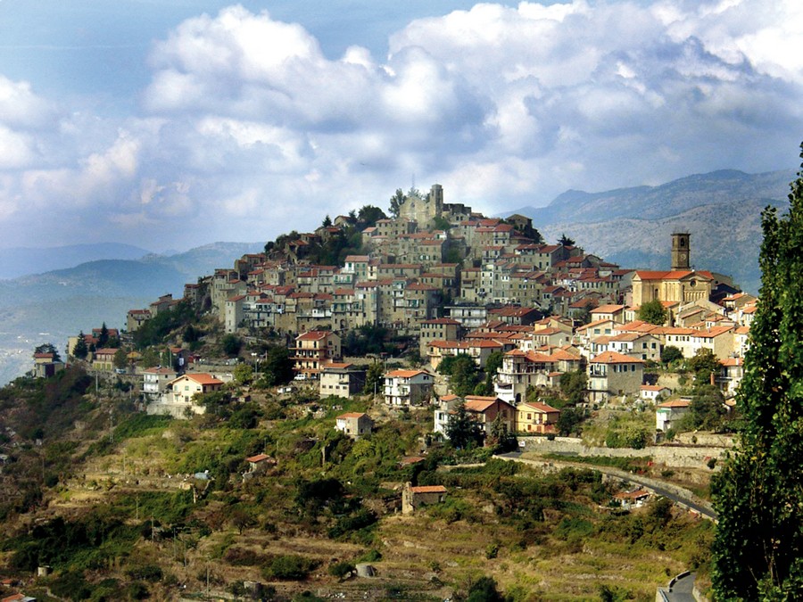
Bajardo is a simple Ligurian mountain village in which the restructuring as second homes of many of its houses, abandoned by the natives in favor of strangers who love the low mountains, overlaps with the way too clear signs of abandonment of its highest and oldest nucleus.
At the beginning of the town, in front of the petrol station, immediately after the deconsecrated church of San Rocco, you can go through the gate and, after crossing the garden, go up the stairs that take you to the modest Civic Art Gallery, open only on Sundays.
A little further on stands the new church of San Nicolò which replaced the destroyed parish church and a little further, roughly frescoed on the façade, is the oratory of San Salvatore which preserves behind the high altar the "Transfiguration" polyptych of 1552 by Emanuele Macario da Pigna.
You can access the oldest part of the village keeping the left and then, at the widening, taking the ramp that goes up to the right under the vault; continuing along the alley that passes under the vaults of the houses with the typical mountain structure, you’ll arrive to the junction with a stone portal with an ogival arch on the left, from which, climbing on the right, you’ll reach the highest part of the village.
Here stood the castle recalled by the “ballad of the boat”, of which however no trace remains having been incorporated into the original Romanesque church which in turn was included in the eighteenth-century church of San Nicolò of which you have the ruins in front of you.
Only the perimeter walls survived the violence of the 1887 earthquake; the entrance is preceded by the small portico on two stone columns with decorated capitals and a cross vault frescoed with a dove; the portal is in black stone with an ogival arch, with a monolithic architrave carved in a Trigram in a tondo, and two half-columns at the jambs.
On the right is the bell tower with loopholes, cut short by the earthquake at the first order of single-light windows, on which rest the ruins of the abandoned rectory.
Along the paved path on the left of the church remain, of the original Romanesque structure, two semi-columns with capitals the same as those later affixed on the new façade, and further on ruins with arches.
Inside the church on the right there are the marble plaque of a private altar of 1731 and the door that leads to the bell tower; further on is the only altar remaining intact, dedicated to St. Anthony, and then the side door that opens on the cobbled churchyard.
On the left of the door, a mutilated plaque engraved with a Trigram between the letters RM and FL is affixed on the external wall; a stone bench lies along the wall.
Go down among abandoned houses along the ramp at the right of the main entrance of the church, and once you have crossed the village, you’ll find yourself in Piazza De Sonnaz where you can take the car again.
Taking the first road on the left, just outside the town, you’ll reach in two kilometers the Romanesque church of San Gregorio, built a little after the year one Thousand.
From Bajardo also originates the dirt road that leads to Pian del Re where, under a pile of over ten thousand stones protected all around by a low wall, a prehistoric tomb was discovered; the archaeological campaigns have recovered flint and jasper artifacts now exhibited at the Sanremo Museum.
Back to the Provincial Road, take the route that goes down to Apricale; shortly before arriving to the village, the detour that leads to the parking lot near the cemetery branches off to the right.
Da Bajardo sale anche la strada sterrata che porta a Pian del Re dove, sotto un cumulo di oltre diecimila sassi protetto tutto attorno da un muricciolo, è stata scoperta una tomba preistorica; le campagne archeologiche vi hanno recuperato manufatti in selce e diaspro oggi esposti al Museo di Sanremo.
Tornati alla provinciale prendiamo la strada che scende su Apricale; poco prima di arrivare all'abitato se ne distacca a destra la deviazione che ci porta al parcheggio presso il camposanto.