
Altitude: 159 m a.s.l.
Area: 10 sq km
Distance from Imperia: 47 km
Inhabitants: in 1881: 1004 - in 2017: 159
Patron saint day: October 8th - Santa Reparata
Information: Municipality phone 0183 382057
After the junction Bastia - Arnasco - Vendone - Curenna - Costa Bacelega return to the beginning of the town of Ranzo and take the junction on the Provincial Road number 14 and at Costa Bacelega take the Provincial Road number 78 which brings you to Aquila D'Arroscia.
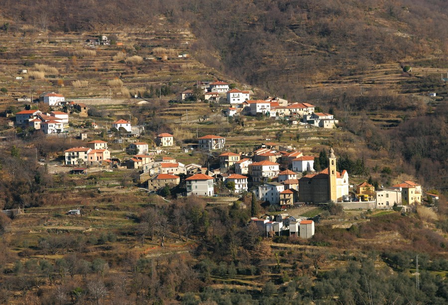
It seems that the toponym - the town was called "Aquila" (i.e. “Eagle”) until 1862 - is linked to the ancient name of the medieval castle called “dell'Aquila”, as, according to a legend, an eagle used to rest on top of it, even if the relationship with the name of the animal could be of a direct nature, given the eminent position of the village.
According to others the toponym would be connected to the noble coat of arms of the local feudal family of the "Cha", on which two eagles were surmounted by a crown.
During the Roman age, the Aquila population - enemy of the Romans – in the course of the second Punic war became allied with the Carthaginians of Hannibal, who they helped when, coming from Spain, he had to cross the Alps.
In the last decades of the early Middle Ages the ancient family of the Cha began to settle in the village; they were perhaps of Flemish origin, as evidenced by the presence of the letter "h" between the "c" and the "a".


Visit of the town
Along the way, you will reach Gavenola: at the beginning of the town stands the church of San Colombano which preserves dramatic processional trunks and twenty-two eighteenth-century angel costumes which, worn by the children of the village, are carried in procession every five years.
Here you’ll also find the Baroque church of Santa Reparata with a faded sundial on the façade and inside on the right a holy water stoup carved with an elaborate angel head.
Aquila was a fief and from 1286 also a permanent residence of Emanuele I of Clavesana.
Continuing to climb beyond Aquila d'Arroscia you’ll see, high in front of you, the ruins of the castle that from 827 meters of altitude still dominates the valleys of the Arroscia and the Pennavaira; of the mighty construction only four sides of the decapitated polygonal tower and walls with remains of battlements remain today.
Near Onzo, on the summit of Mount Castellermo at over a thousand meters above sea level, stands the medieval church of San Calocero, flanked by another castle which was also owned by the Clavesanas and then from 1297 by the Cepollas of Albenga till when it turned into a free Commune in 1581.
The parish church of Onzo which you’ll encounter shortly afterwards on the left continuing by car on the Provincial Road is the church of San Martino Vescovo, with a façade decorated by the fresco of the saint who cuts his cloak to share it with a poor man; the inside preserves a wooden statue of Madonna del Rosario and another one of an angel that are attributed to Maragliano.
Among the various local customs which have now disappeared, it is worth recalling the “spaudo”, which consisted in the obligation, for any young man who wasn’t from Aquila and who intended to marry a girl from the village, to pay a sum in cash to obtain nuptial assent from the inhabitants. These, in the event of non-payment, received the defaulting young man with a shattering beating of pots and bells and with invectives and jokes, nicknamed in the local dialect “trembure”.
At the crossroads take on the right the Provincial Road number 78 and, surrounded by olive trees, you’ll reach Curenna where, after parking the car in the widening on the right of the road, going up the narrow ramp you’ll find the elliptical Baroque chapel of Madonna della Neve and the oratory of the Confraternity of the Guardian Angel.
Just above it is the rustic oratory and finally, near the cemetery overlooking the village, the parish church of San Bernardo.
Yet much more interesting is the sight that awaits you back to the Provincial Road entering the hamlet on the right; after a hundred meters you’ll see where people had the courage to build and others to live in houses built on a rock jutting out over the Paraone stream, dizzyingly suspended on the void of an impressive gorge.
After Curenna you’ll find Vendone; at the beginning of the village there is on the left the funereal church of Sant'Antonino near the cemetery and on the right, behind the monument to the Fallen with an authentic howitzer, the small rustic oratory that also hosted the village school.
Continuing, at the crossroads turn left towards Arnasco and after a few meters park on the roadside. Here on the right lived the Berlin sculptor Reiner Kriester who, following a very personal project of integration between stone, art and nature, erected fifty up-to-three-meter-tall and variously carved stelae of Finale stone in the middle of the countryside.
Following the path that crosses this artwork you’ll reach the mighty sixteenth-century hexagonal fifteen meters high tower built against Saracenic invasions that dominates the whole valley; the structure was part of a larger fortification which has now disappeared and was also used as a prison.
Continuing on the Provincial Road you’ll reach Onzo; entering the village pass the high loggia and the wash house on the left and go up to the left along the paved ramp where you can park in the open space of the first bend.
From here continue on foot taking the path that branches off to the right after the yellow house and that in a ten minute walk through the pine forest leads you to the ruins of the Castle of the Clavesanas that dominates the valley; two octagonal towers ten meters high and part of the walls remained standing.
Return to the Provincial Road number 453 and after a kilometer take the fork to Borghetto D'Arroscia.