
Altitude: 272 m a.s.l.
Area: 20 sq km
Distance from Imperia: 53 km
Inhabitants: in 1881: 2098 - in 2017: 607
Patron Saint Day: September 8th - Sant'Antonio
Information: Municipality phone 0184 208126
The findings testify that, already around 5500 BC, groups of Mesolithic hunters established several camps near the springs on the overhanging Monte Bignone; in historical times Apricale, already a fief of the Counts of Ventimiglia, expelled Count William in 1249 and became a free Commune among the first in Liguria (the Statute dates back to 1247); in 1273, however, it was besieged and conquered by the Genoese Oberto Spinola from whom it passed three years later to the Dorias of Dolceacqua.
In 1524 Bartolomeo Doria became a vassal of the Duke Carlo III of Savoy, who thus definitively acquired control of the village; Apricale would also be devastated two years later by Bishop Agostino Grimaldi, who thus avenged the death of his brother Luciano who was murdered treacherously by the Dorias a few years earlier.


Visit of the town
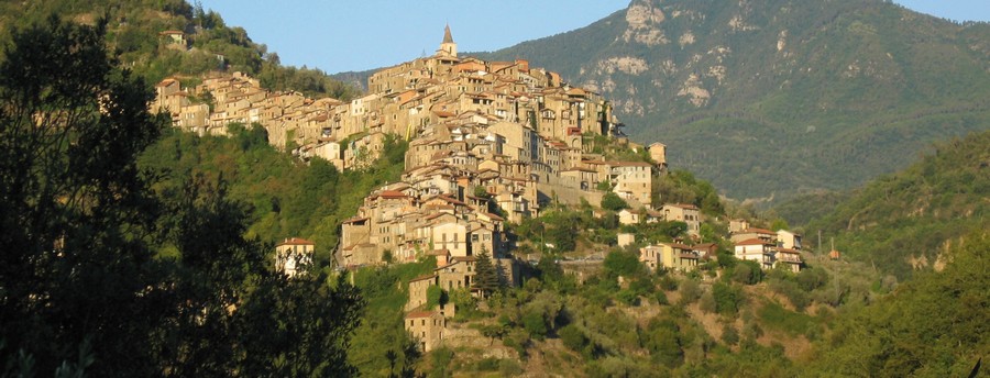
Clinging to the top of a particularly steep hill, Apricale is still perfectly intact today in its most genuine medieval features with concentric circles cut by the steep ramps that connect them.
In the churchyard near which you can park stands the church of Sant'Antonio, built with square stones in the 12th century but then rebuilt with a Baroque façade. Splayed single windows open on the side walls; the apse is enriched on the outside by hanging arches of which the first ones on the left retain traces of the original pictorial decoration, and inside by simple fifteenth-century frescoes.
You can then enter the Town Hall through the beautiful carved door just before the square. In the second room, the originals of the oldest Statutes of the whole west Liguria are displayed, whose well-restored parchments of 1430 show the civil and penal laws of the village in 1247 in the elegant handwriting of the scribe of the time.
Leaving the town hall, you’ll come to the beautiful square on which to your right stands the Baroque Oratorio di San Bartolomeo that preserves the homonymous polyptych; in front of it is the parish church flanked on the right by the medieval castle, whose hanging garden can be seen from there.
Once in the square go left where the tourist office is located at the corner and where, among other things, the booklet with the full text of the statutes is for sale. All around the square there are large loggias, even with stone benches; to the right is the fountain with a large stone basin and three medallions, of which the central one is carved with a lion's head.
Going up the ramp in front of you, you’ll get to the parvis of the Purificazione di Maria church, of late medieval origin but remodeled in the nineteenth century, with two gold background mosaics in the lunette and in the tondo of the facade.
Walk along the right side of the church to reach the simple entrance portal of Castello della Lucertola (lizard's castle), preceded by a semicircular step and flanked by the quadrangular tower with loopholes later used as a bell tower of the nearby church, with few remains of the sundial on the southern side.
Already mentioned in documents of 1092, the fortress was originally the residence of the Counts of Ventimiglia who later ceded it to the Doria family, from whom it later passed to the Savoys. The entrance through a corridor leads directly to the roof garden; the staircase on the left leads to the large upper hall that has been beautifully restored as most of the interior rooms.
Leaving the castle take the alley on the opposite side and, past the various stone arched portals, take Via Fiume on the left, venturing among deep cellars of stone houses until, after coming down the steep staircase, you’ll find the street with brick paving that surrounds the oldest part of the village.
Going left you’ll encounter the thirteenth-century stone gate with an ogival arch that preserves, high on the inside, the massive interlocking stones for the hinges, and on the sides the holes for the iron that barred it. The inscription "1764 - FAME" in memory of a famine is engraved on the right jamb; outside it is still visible above the door the loophole, now walled up, which defended it.
Continuing, you’ll find affixed on the left the architrave of a window with the inscription "IALM"; here is the oldest public oven of the town, perfectly preserved; on its premises - accessible through the staircase a little further on the left - today is the ceramic school attended by the children of Apricale and of three neighboring Municipalities.
Going along the ring road you’ll find under the vault at number 16 a window-door of an ancient shop; immediately after, at number 18, you’ll be surprised by the splendid great-relief carved wooden door, with a beautiful lion's head above a chimera that is devouring a snake. Almost at the end of the descent, just before the restaurant, you’ll find the other thirteenth-century gateway of the southern entrance to the town.
Returning back, retrace the ring road in the opposite direction and, going back under the gate, continue passing the round arched stone portal at number 130 and the monolith carved to make two steps on the right under the vault in front of number 102; under the vault there is a window-door on the left and two others are slightly ahead in front of the numbers 80 and 76.
Above number 70, in front of the small fountain with a stone basin, there is a very deteriorated architrave carved with a Trigram and a heraldic shield. Go back over the ring road and take one of the ramps that go up to your left to return to the square.
From there descend a few steps along the flight of stairs at the corner with the coffee bar to observe the small house on the right with an arch that crosses the alley, not by chance isolated from all the other houses of the village: it was in fact the home of the executioner, an individual who lived only for his work and who hung the heads of those who had been executed on the arch under the house where it’s still preserved the hole in which was fixed the hook from which hung those horrible warnings to non-violence.
Back to the car, continue (without for now taking the road to Perinaldo) along the ring road of the town and park after about five hundred meters, at the short pedestrian ramp that descends on the left taking you to the underlying church of Santa Maria in albis. Of very ancient origin and already mentioned in the Statute of 1262 it was until the end of the seventeenth century the main religious center of the village.
Of particular interest are the anonymous frescoes of the sixteenth and seventeenth centuries that completely decorate the interior, with images of saints and the Virgin that appear seamlessly in the cross vaults and along the walls. The portal is replaced by a large gate; in the jamb (a recovery) at the bottom right is the date 1739. On the left is the box for the alms; inside on the right there is the marble font, and stone seats run along the walls.
The external structure (on the right side of which rests the arch that holds a small room) is best seen from the small terrace with a rustic terracotta fountain in the middle of the descent ramp: the hexagonal apse, with three oculi and small quadrangular windows in the attic, is surmounted by the octagonal dome; on the left is the triangular bell tower.
Back to the car, you can continue to the fork on the right that leads to the restaurant; after travelling this detour for about two kilometers you’ll reach the ruins of the Romanesque church of San Pietro in Ento, built around the year 1000. The roof is sunk, and the structure is in total ruin, hidden among the vegetation that makes it difficult to identify.
Resuming the Provincial Road, go back to the junction from which you’ll turn right and arrive to Perinaldo.
Di particolare interesse sono gli anonimi affreschi del Cinquecento e Seicento che ne decorano completamente l'interno, con immagini di santi e della Vergine che si succedono ininterrottamente nelle volte a crociera e lungo le pareti. Il portale è sostituito da un'ampia cancellata; nello stipite (di recupero) in basso a destra è scolpita la data 1739. A sinistra è murata la cassetta per le elemosine; all'interno a destra c'è l'acquasantiera in marmo, e sedili in pietra corrono lungo le pareti.
La struttura esterna (sul cui lato destro si appoggia l'arco che regge una piccola stanza) è meglio visibile dal terrazzino con rustica fontanella in cotto a metà della rampa di discesa: l'abside esagonale, con tre oculi e piccole finestre quadrangolari nel sottotetto, è sormontata dalla cupola ottagonale; a sinistra c'è il campaniletto triangolare.
Ripresa l'auto, possiamo proseguire fino al bivio sulla destra che porta al ristorante; percorrendo per due chilometri circa questa deviazione raggiungiamo i ruderi della romanica chiesa di San Pietro in Ento, costruita attorno al Mille. Il tetto è sprofondato, e la struttura è in totale rovina, nascosta fra la vegetazione che la rende ormai di difficile individuazione.
Ripresa la provinciale, torniamo indietro fino al bivio da cui prendendo a destra arriviamo a Perinaldo.